


Digital database (DB) and information system for
engineering and social infrastructure of Gabrovo District
The information system of Gabrovo District is a WEB-GIS information system.
According to the assignment, research, software and analytical activities were carried out regarding the design, construction and implementation of an information system for engineering and social infrastructure in Gabrovo District. The information system allows to look at different thematic maps based on a single database for the Gabrovo District, as well as accompanying documentation for the individual modules. To obtain more detailed information about thematic maps, different functions may be used, which are included within the framework of each of the maps.
The digital database provides opportunities to centralize information about sites, facilities and their presentation in a spatial context, as well as opportunities to perform spatial analyzes and references.
- The employees of the Gabrovo District Administration;
- Provided access to the municipal administrations in the Gabrovo District;
- Specialized institutions after requesting the necessary information from the database;
-
BASIC INFORMATION MODULES
-
- Administrative division, urban areas and population
- Transport infrastructure
- Energy infrastructure
- Hydro-economic infrastructure
- Water resources and risk areas
- Social services
- Critical infrastructure
- Protected areas and territories
- Land cover and disturbed terrains
- Cultural and historical heritage and tourism
-
-

See the user interface and information about basic system modules
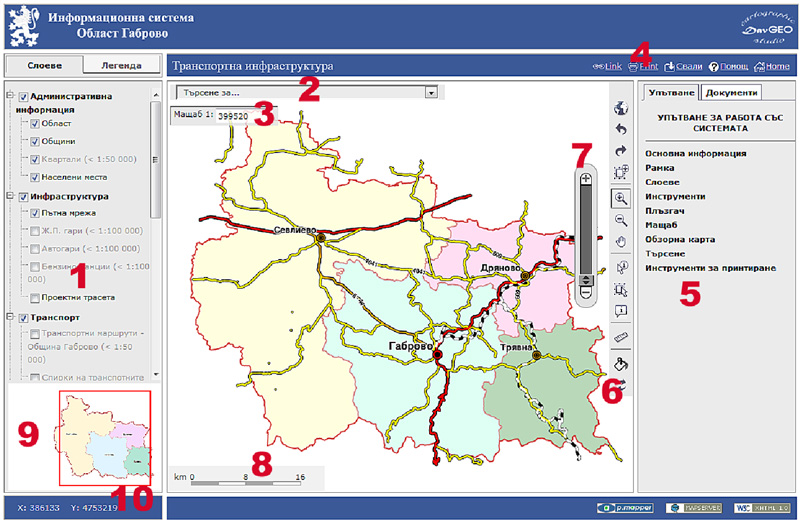
User interface of RIS Gabrovo
-

-
USER INTERFACE
1.Panel – Layers and Legend
2.Search
3.Current scale
4.Instruments for printing and saving the map
5.Panel – Instructions and Documents
6.Toolbar
7.Dynamic scale slider
8.Linear scale
9.Overview map
10.Coordinates
Administrative division
-


-
Administrative division, urban area and population
The administrative module contains data and information for Gabrovo District. The main information that is in this thematic map is about the boundary of the district, the boundaries of the municipalities, the boundaries of lands, neighborhoods, read network and settlements. In addition of the administrative information there is information for boundaries of territories §4 from AOUAL. The administrative map also contains additional information about the relief.


Transport infrastructure
-


-
Transport infrastructure
The module for transport infrastructure of Gabrovo district reflects mainly about the republican and municipal road network and information for transport routes in the individual municipalities.
The road network is represented as linear objects. It is classified according to the road classes (I class road, II class road, III class road, IV class road, main streets, secondary streets, local road, railway roads and railway roads in tunnel). The I, II and III class roads and railway roads and railway roads in tunnel are displayed on the main scale of the map.
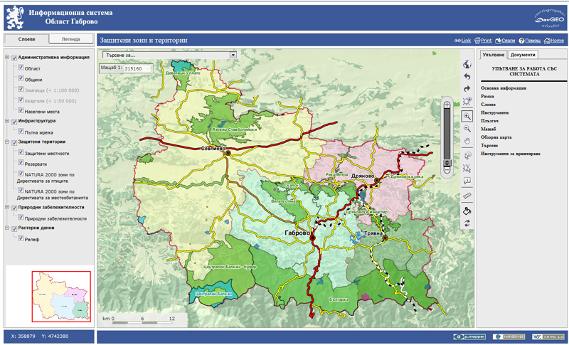
Protected areas and territories
-


-
Protected areas and territories
The module for protected zones and territories contains data and information about the protected zones and territories for the Gabrovo district within the meaning of the Protected Areas Act, as well as the boundaries of the protected territories and protected areas of the Natura 2000 network.

-
If you are interested
in design and implementation of WEB-GIS database, user interface, trainings
- HERE for orders or requests